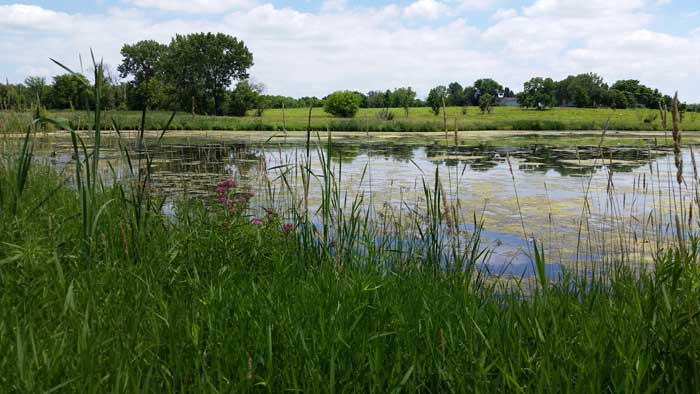
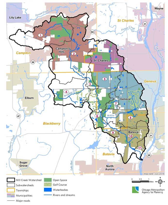
Mill Creek Watershed
Watershed Planning in the Fox River Watershed
The Chicago Metropolitan Agency for Planning (CMAP) received a Clean Water Act grant from the Illinois Environmental Protection Agency (EPA) to develop a watershed-based plan for the Mill Creek watershed, which drains to the Lower Fox River. The 31 square mile planning area includes the majority of four municipalities (Batavia, Campton Hills, Geneva, and St. Charles) and five townships within east-central Kane County.
Mill Creek Watershed Plan
The purpose of this plan is to work with local stakeholders to develop planning, policy, and on-the-ground project recommendations that upon implementation will help improve and protect the water quality in Mill Creek, its tributaries, and the numerous wetlands, lakes, and ponds within this agricultural and urbanized area. The plan must follow Illinois EPA guidelines and is scheduled for completion in September 2019.
Planning partners serving on the steering committee included:
Kane County Div. of Environmental and Water Resources and Development and Community Services Department; Cities of Batavia, Geneva, and St. Charles; Village of Campton Hills; Batavia, Geneva, and St. Charles park districts; Kane County Forest Preserve District; Campton Township Parks & Open Space; Kane-DuPage Soil & Water Conservation District; Kane County Farm Bureau; Wasco Sanitary District; Mill Creek Special Service Area; Garfield Farm Museum; The Conservation Foundation; and Friends of the Fox River.
Contacts:
Holly Hudson, CMAP
312-386-8700
Kelsey Pudlock, CMAP
Rob Linke, Kane Co. Div. of Environmental and Water Resources
630-232-3498
Karen Miller, Kane Co. Planning and Development Dept.
630-232-3418
Holly Hudson, CMAP
312-386-8700
Kelsey Pudlock, CMAP
312-386-8631
Rob Linke, Kane Co. Div. of Environmental and Water Resources
630-232-3498
Karen Miller, Kane Co. Planning and Development Dept.
630-232-3418
Resources & Documents
Mill Creek Watershed-based Plan - Final Draft Sept. 2019
Mill Creek Plan Executive Summary - Final Draft Sept. 2019
Open House Poster 9-27-18 Open House Materials
Mill Creek Steering Committee Kickoff Meeting Agenda 7-18-18
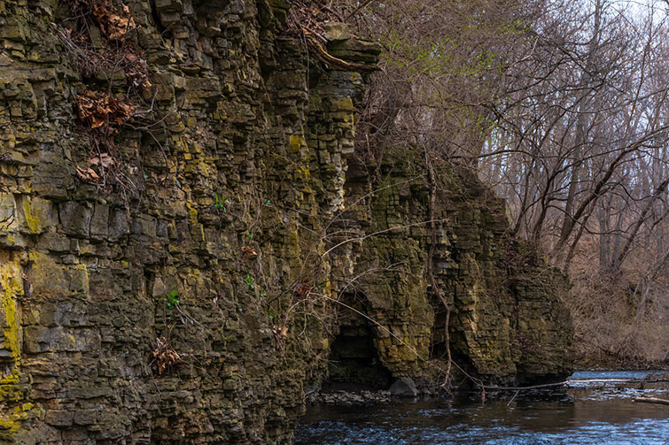
Photos - Below: Mill Creek at Rt. 31, photo by Ken Gortowsi
Right: Mill Creek as it flows downstream through the Garfield Farm Museum grounds, photo by CMAP staff
Mill Creek Plan Executive Summary - Final Draft Sept. 2019
Open House Poster 9-27-18 Open House Materials
Mill Creek Steering Committee Kickoff Meeting Agenda 7-18-18
Photos - Below: Mill Creek at Rt. 31, photo by Ken Gortowsi
Right: Mill Creek as it flows downstream through the Garfield Farm Museum grounds, photo by CMAP staff

PLANNING PROCESS/PROGRESS NOTES:
October 31, 2019
A final draft of the Mill Creek Watershed-based Plan and an executive summary were submitted to Illinois EPA and the project’s steering committee members in early October. This version of the plan is available below under the “Resources & Documents” section.
The Plan includes more than 130 site-specific best management practices (BMPs) identified by stakeholders, as well as a suite of watershed-wide BMP scenarios which account for common BMP types that could potentially be implemented throughout the Mill Creek watershed but are not associated with a site-specific location at this time. BMP opportunities include a variety of urban, agricultural, and hydrologic practices such as permeable pavements, detention basin retrofits, infiltration trenches, rain gardens, vegetated swales, grassed waterways, streamside vegetated buffers, streambank stabilization, and wetland restoration.
Additional watershed protection-related opportunities noted by stakeholders include education and outreach activities and products, coordinated resource management planning, and water quality monitoring programs.
Many thanks are extended to all who participated in the planning process! Following receipt of comments, the Plan will be finalized and posted to the FREP and CMAP websites. Then, the process will begin of putting all those great ideas identified in the Plan into action!
September 24, 2019 The Mill Creek Watershed-based Plan is nearing completion. Pollutant load reduction and planning level cost estimates for more than 100 site-specific best management practices (BMPs) identified by stakeholders, as well as a suite of watershed-wide BMP scenarios, are under development. The watershed-wide BMP scenarios account for common BMP types that could potentially be implemented throughout the Mill Creek watershed but are not associated with a site-specific location at this time. BMP opportunities include a variety of urban, agricultural, and hydrologic practices such as permeable pavements, detention basin retrofits, infiltration trenches, rain gardens, vegetated swales, grassed waterways, streamside vegetated buffers, streambank stabilization, and wetland restoration. Additional watershed protection-related opportunities noted by stakeholders include education and outreach activities and products, coordinated resource management planning, and water quality monitoring programs. A late August version of the draft plan is available below. A final draft of the plan is due to Illinois EPA in early October and will be posted on this webpage as well. Any comments received from Illinois EPA and stakeholders will subsequently be addressed, and a final plan and executive summary will be available on both the FREP and CMAP websites. meeting plan goals of protecting and improving water quality in the Mill Creek watershed and downstream Fox River.
August 29, 2019 Outreach to communities and organizations with a stake in the Mill Creek watershed was wrapped up during August to identify opportunities for planning, policy, education, monitoring, and on-the-ground best management practices (BMPs) to help project and improve water and habitat quality. During the past month, CMAP staff met with the Friends of the Fox River, Lake Charlotte HOA, Fox River Study Group, Forest Preserve District of Kane County Environmental Education Department, and Kane County Planning Division. CMAP staff has mapped the site-specific BMPs submitted by stakeholders in preparation for the next step of estimating pollutant load reductions for applicable BMPs. Additionally, CMAP and Kane County staff developed “watershed-wide BMP scenarios” to account for common BMP types – including infiltration trenches, vegetated swales, rain gardens, permeable pavements, green roofs – that could potentially be implemented throughout the Mill Creek watershed but are not associated with a site-specific location at this time. Pollutant load reductions and planning level costs for both the site-specific and watershed-wide BMP scenarios will be included in the final plan which continues to be developed. The Mill Creek Watershed Planning Steering Committee met on August 27 to review the list and mapped locations of the site-specific BMP submittals and learn about the assumptions made in developing the watershed-wide BMP scenarios. The committee also provided input on interim milestones for documenting progress as well as pollutant load reduction targets toward meeting plan goals of protecting and improving water quality in the Mill Creek watershed and downstream Fox River.
July 30, 2019 A first draft of the Mill Creek Watershed-based Plan was submitted to the Illinois EPA on July 1, 2019. In addition to an updated watershed resource inventory, the plan includes sections outlining recommended watershed protection activities and criteria for documenting success towards achieving plan goals. Over the next two months, details associated with site-specific best management practices (BMPs) submitted by stakeholders will be added to the plan, along with estimated pollutant load reductions and planning level costs for applicable BMPs. Interim milestones and criteria for determining progress will also be specified following further steering committee input. The final plan is scheduled for completion in September 2019. Outreach to communities and organizations with a stake in the Mill Creek watershed continued throughout July to identify opportunities for planning, policy, education, monitoring, and on-the-ground best management practices (BMPs) to help project and improve water and habitat quality. During the past month, CMAP staff met with the Geneva Park District, Mill Creek Water Reclamation District, Garfield Farm Museum, City of Batavia, St. Charles Park District, City of Geneva, City of St. Charles, Kane Co. Farmland Protection program, The Conservation Foundation, Fox River Study Group, and Kane Co. Farm Bureau. A key component of watershed-based plans, BMPs identified in these plans become eligible for Nonpoint Source Pollution Control grant funds through Section 319 of the Clean Water Act. Eligibility for other grant and technical assistance programs also is enhanced. Meetings with interested stakeholder organizations and groups are being scheduled through mid-August to gather BMP ideas to include in the Mill Creek Watershed-based Plan. BMPs can include water quality related on-the-ground projects, policy and planning updates, monitoring programs, and public information/education/outreach products or activities. If you would like to schedule an in-person meeting or phone conversation with CMAP staff, please contact Holly Hudson by August 10, 2019. Also during July, Kane County and CMAP staff continued conducting field assessments of stormwater detention basins to document various characteristics including shoreline erosion, buffer condition, maintenance needs, and retrofit opportunities that could help improve water quality. Assessments will continue during August, and this information will be added to the watershed resource inventory chapter in the watershed plan.
June 2019 Identifying water quality focused best management practices ( BMPs) is a key part of watershed-based plans, especially since BMPs identified in an Illinois EPA-approved watershed-based plan become eligible for Nonpoint Source Pollution Control grant funds through Section 319 of the Clean Water Act. Eligibility for other grant and technical assistance programs may also be enhanced. To facilitate the inclusion of BMP opportunities in the Mill Creek Watershed-based Plan, outreach to communities and organizations throughout the Mill Creek watershed began this month to gain additional input on watershed concerns as well as identify opportunities for planning, policy, education, and on-the-ground BMPs to help project and improve water and habitat quality. So far, CMAP staff have met with the City of Batavia’s Committee of the Whole and Environment Commission, interested citizens in the City of Geneva, Kane-DuPage Soil & Water Conservation District, Forest Preserve District of Kane County, Campton Township Open Space, and Batavia Park District. Additional stakeholder meetings are being scheduled through June. Following the hydrology calibration, the water quality portion of the HSPF (Hydrologic Simulation Program–Fortran) model developed for the Fox River Study Group has been calibrated for the Mill Creek watershed by Geosyntec Consultants. Next, the model will be used to estimate pollutant loads from existing and projected future land use. A future land use dataset is being compiled by CMAP based on the comprehensive land use plans and/or zoning maps for unincorporated Kane County and the municipalities of Batavia, Campton Hills, Geneva, and St. Charles. Lastly, the HSPF model will be used to estimate pollutant load reductions from applicable on-the-ground BMPs identified during the stakeholder meetings. CMAP has nearly completed mapping various physical stream characteristics recorded during the 2018 assessment of channel conditions along Mill Creek. Several elements were documented including bank erosion, hydraulic structures (e.g., bridges, culverts), point discharges (e.g., pipes, ditches), degree of channelization, debris jams, and general riparian condition along the stream corridor. This information will be added to the watershed resource inventory chapter of the watershed plan. (A draft resource inventory is available on the Mill Creek page on the FREP website.) CMAP and Kane County staff are conducting field assessments of stormwater detention basins this spring to document various characteristics including shoreline erosion, buffer condition, maintenance needs, and retrofit opportunities that could help improve water quality. This information will also be added to the watershed resource inventory chapter in the watershed plan.
April 2019 CMAP is nearing completion of mapping various physical stream characteristics recorded during the 2018 assessment of channel conditions along Mill Creek. Several elements were documented including bank erosion, hydraulic structures (e.g., bridges, culverts), point discharges (e.g., pipes, ditches), degree of channelization, debris jams, and general riparian condition along the stream corridor. This information will be added to the watershed resource inventory chapter of the watershed plan. (The resource inventory is available on the Mill Creek page on the FREP website.) CMAP and Kane County staff will be continuing field assessments of stormwater detention basins this spring, documenting various characteristics including shoreline erosion, buffer condition, maintenance needs, and retrofit opportunities that could help improve water quality. The hydrology portion of the HSPF (Hydrologic Simulation Program–Fortran) model developed for the Fox River Study Group has been calibrated for the Mill Creek watershed by Geosyntec Consultants. Next steps will set up the model to estimate pollutant loads from existing and projected future land use. The model also will be used to estimate pollutant load reductions from recommended on-the-ground best management practices (BMPs). CMAP is scheduling outreach to communities and organizations for May and June to gain additional input on watershed concerns as well as recommendations for planning, policy, education, and on-the-ground BMPs to project and improve water and habitat quality.
January 30, 2019 MAP is in the process of mapping various physical stream characteristics recorded during the 2018 assessment of channel conditions along Mill Creek. Several elements were documented including bank erosion, hydraulic structures (e.g., bridges, culverts), point discharges (e.g., pipes, ditches), substrate composition (e.g., gravel, sand, clay), types of fish habitat, and land use/land cover and vegetation types within the stream corridor. This information will be added to the watershed resource inventory chapter of the watershed plan. The HSPF (Hydrologic Simulation Program–Fortran) model developed for the Fox River Study Group is being calibrated for the Mill Creek watershed by Geosyntec Consultants. The model will be used to estimate land use-based pollutant loading as well as pollutant load reductions from recommended best management practices (BMPs). Geosyntec has also developed a framework to help optimize locations for BMPs throughout the watershed to reduce pollutant runoff. Outreach to communities and organizations is being planned for late winter to gain additional input on watershed concerns as well as project and program ideas to protect and improve water and habitat quality.
December 31, 2018 CMAP staff has compiled the information and data collected during the physical stream assessment into a database. A summary and maps are being prepared and will be added to the watershed resource inventory chapter of the watershed plan. The HSPF (Hydrologic Simulation Program–Fortran) model developed for the Fox River Study Group is in the process of being calibrated for the Mill Creek watershed by Geosyntec Consultants. The model will be used to estimate land use-based pollutant loading as well as pollutant load reductions from recommended best management practices (BMPs). Geosyntec also is developing a framework to help optimize locations for best management practices throughout the watershed to reduce pollutant runoff. Over the winter, continued outreach to communities and organizations is planned to gain additional input on watershed concerns along with ideas to protect and improve water and habitat quality.
December 3, 2018 During late October and early November, CMAP and Kane County Water Resources staff were able to begin the task of assessing stormwater detention basins throughout the Mill Creek Watershed. The goal is to identify those that could benefit from retrofitting to help improve their functionality in protecting water quality. In an advance from paper field data entry sheets, staff collaborated to create a “Collector for ArcGIS” app to help streamline data entry using a smartphone or tablet! Snow and freezing temperatures have now curtailed the assessment until next spring. Over the winter, continued outreach to communities and organizations is planned to gain additional input on watershed concerns along with ideas to protect and improve water and habitat quality.
October 2018 A public open house was held on September 27 at the Geneva Park District’s Peck Farm Park. Attendees learned about the watershed planning process and provided input regarding their concerns as well as their ideas to protect and improve water and habitat quality. Nearly 40 community members attended. FREP’s Vice President and Mill Creek watershed resident Maggie Soliz was even quoted in the Kane County Chronicle! Link to article Open House Flyer Open House Posters CMAP staff have put their waders away for the winter after wading through about 13.5 miles of Mill Creek and 6 miles of its tributaries assessing streambank and riparian (streamside) conditions. Several opportunities have been seen for bank stabilization, streamside buffer establishment, and riparian homeowner education. Kane County and CMAP staff are now out and about the watershed assessing stormwater detention basins to identify those that could benefit from retrofitting to help improve their function toward protecting water quality. If you would like to be added to the contact list for Mill Creek Watershed-based Planning news and events, or have any questions about the project, please contact Holly Hudson. The project webpage (link above) will soon be updated.
August 2018 A draft watershed resource inventory (WRI) was submitted to Illinois EPA on July 12, 2018. The WRI includes an overview of the planning area's population and demographics, physical and natural features, land use, water resource conditions, pollutant sources, and land management practices. On July 18, the steering committee met to overview the WRI and provide input on key issues and opportunities in the watershed, as well as recommend public outreach avenues and strategies for the upcoming open house. See the Resources & Documents section below for a link to the draft WRI.